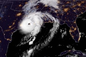
DELCAMBRE, La. — Hurricane Laura made landfall in southwestern Louisiana as a ferocious Category 4 monster with 150 mph winds early Thursday, swamping a low-lying coast with ocean water that forecasters said could be 20 feet deep and unsurvivable. The National Hurricane Center said the storm, which intensified rapidly Wednesday before plowing into land, came ashore at 1 a.m. CDT near Cameron, a 400-person community about 30 miles (48 kilometers) east of the Texas border. “Potentially catastrophic impacts will continue,” forecasters said. Video and photos on social media showed torrents of rain flying sideways past street lights in Lake Charles, and streets covered with water closer to the coast. A sudden storm surge knocked over cameras meant to capture the hurricane’s effects. With hours of violent weather ahead, officials said the extent of destruction likely wouldn’t be clear until daybreak, when search and rescue missions will begin. Drawing energy from the warm Gulf of Mexico, the system arrived early Thursday during high tide as the most powerful hurricane to strike the U.S. so far this year. “It looks like it’s in full beast mode, which is not what you want to see if you’re in its way,” University of Miami hurricane researcher Brian McNoldy said. Hurricane-force winds extending 60 miles (95 kilometers) from the storm’s center neared the coast, forecasters said, and bands of heavy rain fell 30 miles (48 kilometers) from the beach in Lake Charles. Maximum sustained winds increased to 150 mph (241 kph) before nightfall, and forecasters said up to 15 inches (38 centimeters) of rain could fall. Forecasters issued a string of tornado warnings as the storm pushed on to land, but there were no immediate reports of damage. More than 100,000 homes and businesses were without power in Texas and Louisianan. One major Louisiana highway already had standing water as Laura’s outer bands moved ashore with tropical storm-force winds. Earlier Wednesday, winds picked up as shoppers rushed into a grocery store in low-lying Delcambre. Trent Savoie, 31, said he was staying put. “With four kids and 100 farm animals, it’s just hard to move out,” he said. Texas Gov. Greg Abbott and Louisiana Gov. John Bel Edwards fretted that the dire predictions were not resonating despite authorities putting more than 500,000 coastal residents under mandatory evacuation orders. Officials said at least 150 people refused pleas to leave and planned to weather the storm in everything from elevated homes to recreational vehicles in coastal Cameron Parish, which could be completely covered by ocean water. “It’s a very sad situation,” said Ashley Buller, assistant director of emergency preparedness. “We did everything we could to encourage them to leave.” Edwards activated the state’s entire National Guard. In Lake Charles, Guard members drove school buses around neighborhoods, offering to pick up families. Across the state line in Port Arthur, Texas, few stragglers boarded evacuation buses, and city officials announced that two C-130 transport planes offered the last chance to leave. A Category 4 hurricane can render wide areas uninhabitable for weeks or months and knock out power for just as long. The threat of such devastation posed a new disaster-relief challenge for a government already straining under the coronavirus pandemic. The parts of Louisiana that were under evacuation orders included areas turning up high rates of positive COVID-19 tests. The National Hurricane Center kept raising its estimate of Laura’s storm surge, from 10 feet (3 meters) just days ago to twice that size – a height that forecasters said would be especially deadly. On Twitter, President Donald Trump urged coastal residents to heed officials. Hurricane warnings were issued from San Luis Pass, Texas, to Intracoastal City, Louisiana, and reached inland for 200 miles (322 kilometers). Storm surge warnings extended from Freeport, Texas, to the mouth of the Mississippi River. Nick Note: we will not know the extend of damages until daylight And survey crews return to the offshore oil rigs. We have overlayed satellite images:
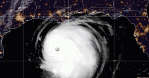 The storm missed the sweet spot of rigs in the Eastern Gulf. Most of the rigs have been spared and the refinery belt in Huston and Galveston bay were spared since the storm went east. As you can see here Houston and most of Texas were not hit. This was not a oil event but a Coonass disaster: